Hunting is an activity that requires a deep connection with nature in order to be called a success. But we cannot be deeply connected to nature if we constantly rely on artificial things—i.e., gadgets. We allow our natural senses to decay when we allow gadgets to substitute for our eyes and ears in the woods. Simply put, excessive reliance on gadgets turns us into pitiful automatons.
Take, for instance, our use of the Global Positioning System (GPS). What do you do when your GPS unit’s batteries are dead? Or your cell phone’s batteries are dead and you cannot use its GPS app? Clearly, it behooves us to develop our common sense regarding navigation in the woods. (In case you mistake me for a Luddite: As an engineer I have worked in industries from aerospace to consumer products, so I am very accustomed to high tech. But when I am outdoors, my equipment is as basic as possible.)
To navigate in the woods, I shun GPS and instead use what I call CPS—Common-sense Positioning System. It requires good perceptive skills, but no high-tech gadgets. Instead, just low-tech tools—a wristwatch with hour and minute hands, and maybe a compass—can be part of your CPS.
Usually, hunters get lost in the woods because they did not carefully observe the things they passed on their way into the woods, things such as a fallen tree, a ditch, etc. Using CPS means you must be observant, so if you do get lost, there is at least one known point from which you can backtrack.
Assume you are lost somewhere in North America, and your GPS and cell phone are dead. The only thing you know is your general location: You are north of some landmark such as a stream you crossed on the way in, and you know you need to head south.
Your basic wristwatch (set to the correct time) with a face can help. Line up the hour hand with the sun. Notice the angle between the hour hand and the 12 o’clock mark on the dial. Imagine a line that cuts that angle in half. That line will point south. Obviously, once you find south, you can find north, east and west.
If your wristwatch stops working, resort to an ancient but reliable technique. Drive a stick into the ground. Carefully mark the end of the shadow with a stone, pinecone or other small object. Wait about 30 minutes. The shadow will have moved several inches. Mark as before. Now draw a line through the two marks. That gives you the east-west line; the second mark points east. Draw a line perpendicular to this east-west line to indicate north-south.
Of course, if it is late afternoon you can use the sun’s western setting as a guide, since it sets at or near west. Likewise, in early morning, you can use its eastern rise.
If it is so cloudy you cannot see the sun at all, there are some natural clues you can use, but use them collectively, instead of relying on one clue alone. Observe the trees carefully—they tend to have more foliage and/or branches on the side facing south. (The sun’s path across North America is such that more sunlight comes from the south, favoring south-facing branches.) If you are in an area where the wind generally comes from only one direction, then you can use that as a guide. Another aid is moss, which generally grows on the north side of rocks, trees, etc.—but beware that moss can grow on any side that remains damp in thick, shady woods.
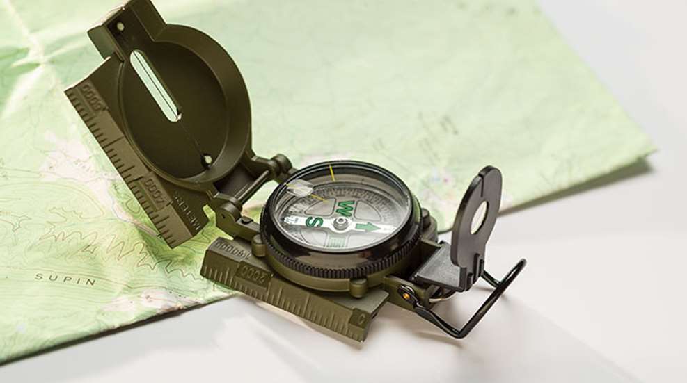
However, much frustration can be prevented by carrying a basic compass of good quality. CPS means using common sense, and there is a lot of sense in carrying a compass. A compass is much more reliable than a GPS unit. First, you never have to worry about batteries. Second, GPS depends on signals from satellites in orbit—no signal, no directions. But a compass will work as long as the earth has a magnetic field—which it has had for millions of years. And it’s free for anyone to use, unlike the signal from your phone provider. (Granted, there is a slight difference between magnetic north and true north; technically called the magnetic declination, it’s insignificant for most hunts.) Besides, a compass costs far less than a GPS unit. And a compass is lighter and smaller, a factor that matters in hunts requiring long hikes.
A topographic map (showing land features, elevation, etc. in detail) is an invaluable accessory to a compass. Even a large topographic map, say 30-by-30 inches, is very light, foldable and fits in your cargo pant pocket. Imagine carrying a GPS monitor that big. One more thing: The map won’t break no matter how many times you drop it. In short, with a compass and a topographic map, you cannot get lost unless you are totally careless.